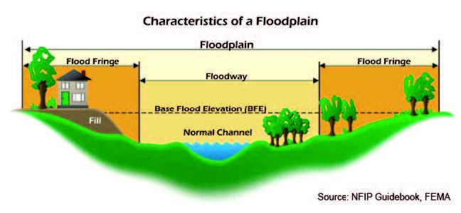
Flooding is a natural function of a floodplain. People have been attracted to the creeks within the City of Austell for many reasons related to the benefits provided by floodplains. Our rivers and floodplains have provided our community with recreation.
Floodplains are important for the natural storage and conveyance of flood waters, the protection of water quality, groundwater recharge, and the preservation of our local ecosystem. They provide both physical and biological benefits. Preserved floodplains reduce the severity and frequency of floods. They can also provide opportunities to learn about the natural environment and for recreational opportunities.
Natural Flood and Erosion Control
Over the centuries, floodplains develop their own ways to handle flooding and erosion with natural features that provide floodwater storage and conveyance, reduce flood velocities and flood peaks, and curb sedimentation. Natural controls on flooding and erosion help to maintain water quality. Floodplains do this by filtering nutrients and impurities from runoff, processing organic wastes and moderating temperature fluctuations. These natural controls also recharge groundwater by promoting infiltration and refreshing aquifers.
Biologic Resources and Functions
Floodplains enhance biological productivity by supporting a high rate of plant growth. This helps to maintain biodiversity and the integrity of ecosystems. Floodplains provide excellent habitats for fish and wildlife by serving as breeding and feeding grounds.
Societal Resources and Functions
Floodplains enhance the quality of life for those living and visiting the City of Austell, a role that can be undervalued. Parks, bike paths, open spaces, wildlife conservation areas, and the aesthetic features they provide are important to many citizens. Assets like these help make our community more appealing to potential employers, investors, residents, property owners, and tourists.
Related Links and Documents
Stream Buffer
National Wetland Inventory - Surface Waters and Wetlands
The City of Austell uses National Wetland Inventory as a map of the city’s community natural areas. The National Wetlands Inventory mapper provides users with information on wetland and deepwater habitat location, extent, type and change to promote the understanding and conservation of America's wetlands. Under find location box, please type 'Austell'.